====== Options:
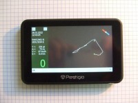
- shows current GPS data (Date, Time, Lattitude, Longitude, Altitude, Direction, Speed, maximal
Track's speed, total Track's length);
- shows Compass while moving;
- shows current Track (Way) as a curve;
- writes Track's GPS data to the file «VIWay.txt«;
- possibility Zoom drawn Track (+ or -);
- possibility drag drawn Track by your finger;
- works with Windows CE 5.0 and more;
- uses no maps;
- is small (about 30 KBytes exe file);
- uses about 1% of processor's resources only;
====== How to install VIWay:
- unzip the downloaded file «VIWay.zip«;
- copy unzipped directory «VIWay» to any place of your Windows CE device;
- change ComPort number and BaudRate inside the file «VIWay.ini» according your GPS device;
====== How to use VIWay:
- run VIWay.exe;
- at the left Panel you will see current:
* Date (as dd.mm.yyyy);
* Time (as hh:mm:ss GMT);
* Lattitude (ggmm.mmmm N/S);
* Longitude (ggmm.mmmm W/E);
* T = Direction of moving (as grads, 0 grads is Nord);
* A = Altitude (as meters);
* V = Max Speed for all Track (as km/h);
* S = Total length of all Track (as km);
* 0 = Speed (as km/h);
- at the top of left Panel you will see two small buttons «Z+» and «Z-» (they make Zoom more or
less);
- at the right side you will see a Track window with a Compass and Track's curve.
- Compass shows the real Nord when you are moving;
- Track is started from the center of window as a small green circle and is moving according your
way. It is moving to the top of window when you are moving to the Nord, to the left when you are
moving to the West etc;
- you can drag the Track with your finger;
- GPS Data is being written to the log file «VIWay.txt» as:
* Time (as hh:mm:ss GMT);
* Lattitude (ggmm.mmmm N/S);
* Longitude (ggmm.mmmm W/E);
* Speed (as km/h);
* Direction of moving (as grads, 0 grads is Nord);
* Altitude (as meters);


