Скачать GIS ObjectLand
Geographic Information System ObjectLand
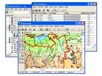
GIS ObjectLand is a universal Geographic Information System for Windows.
Key features:
- creation of vector-raster maps with arbitrary structure of layers and feature types in an internal ObjectLand database or in following DBMSs - MS SQL Server, Oracle, DB2, MySQL, Interbase/Firebird, PostgreSQL, MS Access;
- creation of themes. Theme is a user presentation of a map;
- control of displaying features depending on the chosen scale;
- spatial data input and editing by assigning feature coordinates and also by interactive drawing with mouse or digitizer;
- sewing of separate pages of an imported map into one unified continuous map;
- copying, merging, and moving maps, layers, and feature types between different geoinformation databases;
- creation of tables of arbitrary structure;
- creation of queries. Query is a user presentation of table built by setting search and sorting conditions, joining tables, calculations and using reference tables;
- copying, merging, and moving tables and queries between different geoinformation databases;
- setting arbitrary links between spatial and table information;
- getting information about the feature selected on the map;
- searching for features on the map by linked records;
- creation of filters. Filter is conditions of feature visualization depending on spatial properties of features and linked table data;
- creation of layouts. Layout is an output form combining spatial, table information and presentation elements;
- import and export of table and spatial information for widespread data formats;
- support of style libraries containing fonts, map symbols, line styles, hatches and fill styles;
- style editors for displaying styles;
- setting for users the access permissions to components;
- multiuser data editing;
- using and editing tables of external database (via ODBC) as linked tables;
- providing automation COM interfaces for user applications.
Скачать GIS ObjectLand бесплатно на странице загрузки.
GIS ObjectLand 2.7.9
Основная информация о программе
Разработчик
Лицензия
Версия
Дата релиза
Размер файла
Операционная система
Семейство
Версия ОС
Win98
WinME
WinXP
WinNT 4.x
Windows2000
Windows2003
Требования
Популярность у пользователей
Рейтинг
Голосов
Статистика просмотров
За сегодня
За неделю
За все время
Статистика загрузок
За сегодня
За неделю
За все время
Дополнительная информация
Дата изменения
Ключевые слова
Скачать GIS ObjectLand 2.7.9
ObjectLand
GIS
geographic information system
geoinformation system
MIF
MID
SHP
DXF
DBF
CSV
cadaster
cadastre
cartography
topography
geodesy
geomatics
GIS technology
GDB
geoinformation data base
map
table
theme
view
layout
query
layer
features
geo
Популярные программы рубрики