RoboGEO
Geocode digital photos.
для Windows
- ВКонтакте
- РћРТвЂВВВВВВВВнокласснРСвЂВВВВВВВВРєРСвЂВВВВВВВВ
- РњРѕР№ Р В Р’В Р РЋРЎв„ўР В Р’В Р РЋРІР‚ВВВВВВВВРЎР‚
- Viber
- Skype
- Telegram
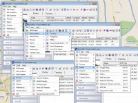
Geocode digital images with latitude, longitude, altitude, and direction information. RoboGEO stamps this information onto the images or writes it to the EXIF, allowing you to permanently geocode and link your photos to the GPS coordinates. All writing to the EXIF and IPTC headers is lossless and all of the existing comments (including the MakerNote and the Adobe XMP metadata) are preserved. Includes a Picasa-style geotagger for Google Earth. Create web pages that use Google Maps, export KML or KMZ files to Google Earth, upload geotagged photos to Flickr, export ESRI SHP shapefiles, export to MapPoint, or export DXF files to AutoCAD or IntelliCAD. Show the photo direction on maps and calculate it from the GPS tracklog. Merge EXIF or IPTC tags into the image titles and descriptions. Record dictation using any modern digital voice recorder and automatically associate audio with the photos. Rotate or redate images based on the EXIF info. Export GPX files. Edit the EXIF times. Lookup altitudes knowing only lat/lon. Photo locations can be projected to a new location in either ground or airplane mode. Free EXIF/IPTC viewer. Geocode any type of JPG, PNG, BMP, TIF, DNG, NEF, CR2, MRW, ERF, RAF, ORF, PEF, ARW SR2, SRW, RW2, RAW, RWL, and MEF. Directly supports Garmin GPS units (USB or COM), but no GPS is required. Geocode images from a GPS tracklog, KML or KMZ files, NMEA sentences, waypoints, known place names OziExploer PLT files, or TCX files. Import GPX files for interfacing with other GPSs like Magellan and Trimble. Import shapefiles. Rename images per the EXIF data. IPTC editor. UTM and MGRS support. Use any digital camera. Internationally aware. Very easy to use. Nice user interface. Can be fully automated from the command line. Perfect tool for aerial photography, land surveyors, engineers, insurance claim adjusters or anyone who needs to collect field data for integration into a GIS system. Affordable. Free lifetime upgrades. Extensive documentation.
Скачать RoboGEO бесплатно на странице загрузки.
RoboGEO 6.3.2
Основная информация о программе
Разработчик
Рубрика
Лицензия
Версия
Дата релиза
Размер файла
Операционная система
Семейство
Версия ОС
Win7 x32
Win7 x64
WinOther
WinServer
WinVista
WinVista x64
WinXP
Other
Требования
Популярность у пользователей
Рейтинг
Голосов
Статистика просмотров
За сегодня
За неделю
За все время
Статистика загрузок
За сегодня
За неделю
За все время
Дополнительная информация
Дата изменения
Как вы оцениваете программу RoboGEO 6.3.2?
Оставьте отзыв о программе RoboGEO 6.3.2
Пожалуйста, оставьте несколько слов о программе RoboGEO, чтобы помочь другим пользователям выбрать достойный программный продукт из представленных на нашем сайте. Возможно, именно ваше мнение станет решающим в пользу того, чтобы заинтересованный человек мог скачать RoboGEO, уверенный в том, что именно эта программа ему необходима.
Ключевые слова
Скачать RoboGEO 6.3.2
geocode
georeference
geotag
photo
image
EXIF
GIS
NMEA
GPS
Google Earth
Google Maps
Flickr
MapPoint
Garmin
AutoCAD
DNR
shapefile
SHP
DXF
KML
KMZ
latitude
longitude
tracklog
waypoint
GPX
DNG
JPG
NEF
CR2
MRW
ORF
ERF
RAW
Популярные программы рубрики