Geodata Germany
Geodata of the Federal Republic of Germany.
для Windows
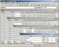
The database tables contains geodata of the Federal Republic of Germany with geo referenced towns, municipalities, town quarters and other administrative units, postal codes, telephone preselections, nature areas, landscapes, climatic zones and official topographical cartographies. The data contain coordinates for navigation and geo-coding, proximity searches and distance computations and are prepered for the spatial mapping of environmental information. Quite often it is necessary to reference an address field e.g. like town or municipality name, postal code or telephone preselection, to corresponding geographical data and coordinates - a Geo Reference. The geo reference can be used e.g. to direct a customer to the closest store locations of a retail store chain by doing a proximity search. Another possibility it to determine distances between the different objects of the database tables with the included geo references. With the elevation data from a Digital Elevation Model the ground level height of each place can be determined. Often the knowledge is necessary about affiliations and relationships between data derived from different hierarchies. So it can be determined to which federal state, governmental area or governmental county a town, a postal code or a telephone preselection is associated. It is possible to assign a variety of natural and scenic information to each town or municipality. The snow and wind load zones and solar irradiation are available as local climatic data. In conjunction with the ground level heights they can be used to calculate static loads for the planning of building constuctions and to calculate solar installations. Databases: 11.000 Towns and Municipalities, 108.000 Town Quarters, 30.000 Postal Codes, 19.000 Telephone Preselections, all with geo references, 400 Administrative Countys, Administrative Districts, Federal States of Germany, Landscapes, Nature Area Classification, Snow and Wind Load Zones, Solardata, Cartographies.
Скачать Geodata Germany бесплатно на странице загрузки.
Geodata Germany 18.01
Основная информация о программе
Разработчик
Лицензия
Версия
Дата релиза
Размер файла
Операционная система
Семейство
Версия ОС
WinVista
WinVista x64
Win7 x32
Win7 x64
Win2000
WinOther
Mac OS X
Windows2000
Windows2003
WinServer
Windows Vista Ultimate
Windows Vista Ultimate x64
WinMobile
Windows CE
Android
BlackBerry
Win98
WinME
WinNT 3.x
WinNT 4.x
Win95
Unix
Linux
Handheld/M
Требования
Популярность у пользователей
Рейтинг
Голосов
Статистика просмотров
За сегодня
За неделю
За все время
Статистика загрузок
За сегодня
За неделю
За все время
Дополнительная информация
Дата изменения
Как вы оцениваете программу Geodata Germany 18.01?
Оставьте отзыв о программе Geodata Germany 18.01
Пожалуйста, оставьте несколько слов о программе Geodata Germany, чтобы помочь другим пользователям выбрать достойный программный продукт из представленных на нашем сайте. Возможно, именно ваше мнение станет решающим в пользу того, чтобы заинтересованный человек мог скачать Geodata Germany, уверенный в том, что именно эта программа ему необходима.
Ключевые слова
Скачать Geodata Germany 18.01
geo
data
geodata
coordinate
coordinates
periphery
proximity
search
nature
area
landscape
snow
wind
load
zone
solar
irradiation
elevation
sea
level
sealevel
distance
calculation
branch
reference
coding
longitude
latitude
Популярные программы рубрики